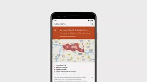
Google at the IO 2019 revealed that as part of its AI For Social Good initiative it will be expanding on the work done in collaboration with Central Water Commission of India to include more areas around Ganga and Brahmaputra in its flood prediction and warning program.
Google’s Jeff Dean, one of the company’s top scientists and one of the key AI experts in the world, revealed at the IO 2019 that in the coming Monsoon season Google and Central Water Commission will not only try to cover more areas in the north and east India where floods are likely to occur, but will also try to predict the severity of floods. Whenever Google’s AI finds the possibility of devastating floods in these areas, real-time alerts will be sent to people who could be affected by the rising water.
He further added that with AI For Social Good we are trying to tackle some of the world’s most challenging problems. One project that we are working on and which is already creating an impact is the flood forecasting, said Dean. Last fall we shared our work on the flood forecasting model that can predict flood timing, location, and severity. Today we are announcing the extension of flood detection and alerting system for the upcoming monsoon season. The expanded area will cover millions of people.
Google says that it makes the flood prediction using high-resolution satellite images that are analysed by its AI machines using neural networks fancy name for computing that is modelled after the way human brain works and some smart algorithms.
Dean said, “Our model simulates how water spreads showing the exact areas that will be affected. This we do by combining thousands of high-resolution satellite images to create high-resolution elevation maps that detail the height of the ground. We then use neural networks to correct the terrain so it is even more accurate and then we use physics to simulate how flooding will happen. We also collaborate with the government to get stream gauge measurements and then send forecast (to people at risk from the flood) in real time.”
Google’s AI and machine learning teams first used their expertise for creating flood prediction model in India last year.
In a paper presented by Google engineers in 2018, they noted, we developed and recently deployed an operational hydro-dynamic model, in a pilot area around Patna, India with the explicit goal of preparing the ground for integrating machine learning models into the process. The model receives real-time measurements and short-term forecasts of river water levels in real-time and produces an inundation map estimating the flood extent. Based on past events, our model’s flood extent estimates are accurate down to a spatial resolution of 300 meters, achieving over 90 percent recall and over 75 percent precision.

Leave a Reply